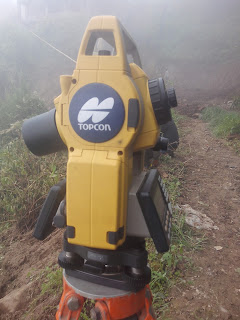
Total station: It is a optical / electronic instrument which is mostly use for Surveying a land before start any project like Road,Bridge,Building,railway,Airport,Boundary survey and Construction.
It is also widely applicable to find distance coordinates and height of any object with Precise. From total station we can measure distance,Height,Level of any object or for any Project .For this we need to setup Total station and enter data that we observed from this instrument and later we can output data from this machine and plot on Auto cad to create traverse,Drawing,Boundary work ,Setting out of any project ,counter of existing area ,to find cross-section area and many more.There are lots of total station available in market but today i am going to teach you how to input data and layout on ground by using coordinates that given from total station Using Topcon E-series Total station.With the functionality of many high-end robotic total stations, our ES series is full-featured and ready to tackle modern job site.
Features of Topcon E-series Total Station:
- Long return of prism distance measurements, out to 4,000m
- TSshield™ web services for streamlined maintenance and security
- Topcon's LongLink™ communication at 300m
- Rugged IP66 environmental rating
- Provides 36 hours of battery life
Steps for layout using Topcon E-series Total Station:
Step 1:-
1. Fix/set the instrument at station point which coordinates is known.
2. Then exact centering should be done.3. Fix tilt that should be all bubble is in centre. (To check leveling)
4. Press ESC
5. Press FUNC for Menus
6. F3: Go to TOPO
7. Choose Occupy. Station
8. Coordinate:-Put N, E, Z, HI of Station point
9. Ok
Step 2:-
To Check Instrument: Input Data for another Known Point (Back Sight)
1. Press Menu bottom or Esc to go back sight:
2. Coordinate
3. Put N, E, Z, PI (prism Height) of another known Point (Back sight Station)
4. Sight to prism at known point (BS station)
5. MEAS: to measure data
Note: - Check- If previous enter NEZ data and after measured NEZ Data are same then instrument is ok.otherwise again setup machine or change for another location.(Permissible error: mm to 2 cm)
6. REC: - To record known point data
For Layout New point (To find out Unknown Point on ground)
1. Press ESC for Main menu
2. Go to S-O Data: to search ordinate of unknown Point
3. Enter
4. Coordinate
5. Put NEZ of Desire Point
6. Now rotate Device and sight on prism. Rotate machine horizontally until it shows HR:(Horizontal Angle) Zero 0 0'0".Thats the desire point's line direction.
10. Click MEAS
11. If -ve then put prism back, +ve then put prism forward on that line. it should me exactly zero (Distance Should be 0). Thats the desire point.
Step 4:-
Repeat Step3: Procedure to find out others unknown points
THANK YOU!!!


0 Comments
Dear Viewers if you have any comment regards this post let me know.